
PATTERNS IN THE LANDSCAPE
Wollumbin is awakening and therefore so are we
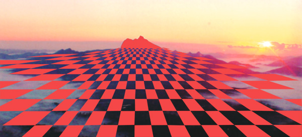
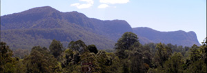
One of the most remarkable observations while mapping temple sites across the planet is that every place of significance has its own particular energy signature embedded in the landscape. It is only the very oldest temples that are aligned to the pattern, such is the case at the Angkor Wat complex in Cambodia. In the area where I live the pattern is generated by Wollumbin as I have depicted in the above picture.
 Close to the mountain prior to early in 2013 the pattern consists of a 1m square grid a bit like a checkerboard, where the red squares are a charging field and the adjacent squares contain no energy. Then at the extremities of the mountain's influence the pattern becomes larger and more
spread out and the energy field is weaker or less potent. However in February 2013 we had a huge flood event which caused landslips on the mountain, blocking the summit track for 6 months. After this event I noticed that the frequency of the mountains vibration as dowsed through its energy signature had increased three fold. From this time on the checkerboard squares that radiate through the landscape are only 30cm each side where formerly they were around 1 metre. A frequency change like this indicates some movement in the awakening process for the landscape which in turn will affect our own consciousness. People who live in this rainbow country under the influence of Wollumbin will be living in a higher frequency world. Things can happen in this region that may not get traction in another place that is not running at such a high frequency. When this North coast area under the influence of Wollumbin becomes a true centre of spiritual integrety I would expect the energy signature to be all circles with possibly a transition period of hexigrams.
The mountain itself is a continuous charging field which can be felt at aproximately the point where you walk through the visitor counter infra red device that is on the summit track not far from the car park. You don't have to go to the summit to be totally imersed in the mountain's energy field.
Following the pattern while going on trips in the car I found that the pattern had definable boundaries that I could mark on a map. In the North I found it all the way to the banks of the Logan River just north of the Gold Coast while in the South it goes down to the Clarence River and West almost to Tenterfield and East to the adjacent coast. When traveling further North of the Logan river [Gold Coast QLD] a slightly different checker board pattern predominates the landscape and is centered around the Glasshouse mountains.
You could say the land has a particular song in a particular place. Apparently indigenous people used to sing to the land and the land would provide an abundance of food and resources. In cultures where no maps or fences are used the language groups could identify their ancestral land from another tribes territory by the song or vibration eminating from the landscape.
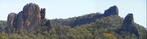
Mt Terragon
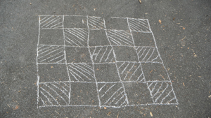
 This next pattern covers a ridge known as Mt Terragon on the south side of Wollumbin which is visible in the background. I took the liberty of drawing the pattern on this rock flat along a creek in chalk then I have coloured in the bands of energy on a computer. This pattern is not scaled but is the actual size. The grid lines are 200mm wide as are the centre squares. It is a charging field pattern and dominates the area to the extent that the Wollumbin pattern can not be detected. Where the grid lines intersect the energy is particularly potent. It appears to me as a net with its own particular song. Because I have been watching this energy signature for 15 years and have observed the effect it has on the people who have occupied this land I am convinced for the moment that it has to do with Aboriginal business. There has been some rather wrestles spirits who break up relationships between people and drive women away and I believe this net has been sung into this place and holds these spirits to this place so they can not cause mischief throughout a wider area. It has always felt like a heavy spiritual place of very strong vibration and because this net is made of charging field energy the land cannot be considered to be geopathically stressed but at the same time I
wouldn't choose to live there as this energy field is just too strong.
Mt Burrell
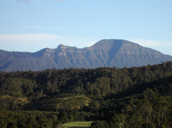
Between Mt Burrell [ left]and Hanging Rock [Lofts Pinacle] [right] the landscape is saturated with the energy signature of the Clever man who once had dominion over this country. He is at this very moment singing up this land from the 4th dimension and should he stop singing this pattern would disappear. His song could also be considered an enchantment which marks out his field of
influence which is 5.6km wide and appears between these
2 significant landforms. This localised energy pattern sits on top of the Wollumbin pattern and seems to dominate the area.
The clever man's song appears as bands of charging field energy 1metre wide which gets stronger as you approach his burial place below Hanging Rock. People living nearby have encountered seeing his spirit. The enchantment has a very heavy dreamlike quality about it which makes it very supportive of spiritual endeavors.
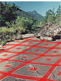
Nimbin Rocks
The area around Nimbin Rocks has its own unique energy signature which consists of 2 interlaced grids. One grid is charging and the other is discharging. I have shown the charging grid in red and the discharging grid in blue.
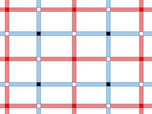
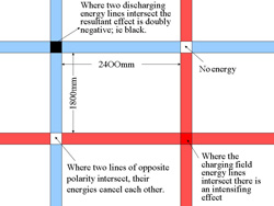
The energy lines which make up this grid are 200mm wide.
Where the charging lines intersect 'hot spots' are created and where the discharging lines intersect 'black spots' are created.
The area around the rocks where this grid persists should not be lived upon as the energy here is too strong and you can not avoid being caught up in this net like grid. In her book 'My Bundjalung Country' author Ruby Langford Ginibi says that Nimbin Rocks is the burial place of her tribal elders, the Law givers. It is so sacred that they use a branch to brush their footprints off the ground. It is my belief that this grid pattern is marking out the enchantment of the hairy man spirit known as Nimbunji. These hairy men are also known as Yowies. This energy net is also binding spirits to this place.
Uki village Songline and Moon Circle
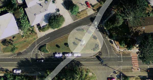 For many years I have been aware of the Songline which runs through the War Memorial triangle in the heart of my local village of Uki and since we are collectively awakening in a flowering of consciousness across our planet I feel that it is now time that people are more able to accept and explore for themselves information which has previously been hidden by skepticism. The War Memorial triangle is also the site of a rather remarkable Earth Energy vortex which I call a Moon Circle. Moon Circles are a reflection of the Moon upon the Earth and only occur on Songlines. They exhibit the same clockwise spinning charging field energy as the Songline however they also expand and contract with the phases of the Moon. On a full moon this ring of earth energy expands to about half way across the roads bounding the triangle which gives it a 25m diameter and on a new moon it will contract to a little hub in the centre.
By the way Songlines like this one that are involved with the maintenance of the planet are never straight but meander like a serpent, hence their connection to the Rainbow Serpent.
What does it all mean and what is its purpose? For an understanding of the function of Moon Circles and Songlines we have to look at the knowledge held by our Indigenous Brothers and Sisters whose Spiritually base culture has kept them in touch with the Earth and the cosmos. The Moon circle is a place where the magnetic moon energy is very strong and allows us to more easily bridge the gap between our Earthly world and the dimensions of spirit.
Moon Circles
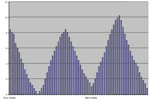
The adjacent graph shows the daily expansion and contraction in the diameter of a typical Moon Circle. I monitored the diameter variation daily for 3 months in order to get the figures for this graph. The troughs indicate the circle size at new moon while the 3 peaks in the graph are the circle diameters at full moons. Note that the small new moon circle size differs from month to month and the full moon circle diameter [far right hand peak] is much larger than the previous full moon. Some full moons are stronger than others and some new moons are more absent of moon energy. Moon circles arent particularly common and only occur along Songlines. If you check the variations in low and high tides you will find the same variations occuring in the diameters of the Moon Circles.
To be continued.......